by SPC Forecast Products | Nov 12, 2024 | Weather and Emergency Alerts
SPC 1930Z Day 3 Outlook

Day 3 Convective Outlook
NWS Storm Prediction Center Norman OK
0113 PM CST Tue Nov 12 2024

Valid 141200Z - 151200Z

...NO SEVERE THUNDERSTORM AREAS FORECAST...

...SUMMARY...
Organized severe thunderstorms are not currently expected on
Thursday.

...Synopsis...
A negatively titled shortwave trough is forecast to extend from the
Upper Midwest into the southern Appalachians early Thursday morning.
This trough is expected to lose amplitude as it continues eastward
while also developing a closed mid-level circulation. This resulting
cyclone will then likely progress across the Upper OH Valley and
into the Mid-Atlantic by early Friday. In response to this
evolution, surface cyclogenesis is anticipated off the Carolina
coast, or perhaps just inland over the coastal Carolinas.

Farther west, the overall upper pattern will amplify as ridging
builds across the Plains and troughing deepens along the West Coast.

...Central/Northeast Gulf Coast vicinity...
Showers and thunderstorms will likely be ongoing over the central
Gulf Coast early Thursday morning, as a cold front pushes eastward
through moist and modestly buoyant warm sector in place across the
region. Northern extent of this warm sector is expected to become
increasingly confined throughout the day with the cooler, more
continental airmass over the Carolinas and Mid-Atlantic remaining
place. A strong storm or two is possible within this warm sector,
particularly Thursday morning from southwest/southern AL into the
western FL Panhandle, but limited buoyancy and weakening shear
should keep any severe threat isolated, precluding the need for any
severe probabilities with this outlook.

...Coastal Carolinas...
Uncertainty regarding the strength and location of the surface low
expected to deepen over the region late Thursday night/early Friday
morning limits the confidence on how far inland any favorable
low-level moisture/buoyancy would penetrate. Current guidance
suggests there could be a confined area along the warm front near
the northern NC Coast where there is enough overlap between modest
buoyancy and strong shear to support some severe potential. Given
the limited spatial extent of this region and the general
uncertainty regarding the overall pattern, no severe probabilities
were introduced with this outlook. However, a small area maybe
needed in future outlooks if forecast confidence increases.

..Mosier.. 11/12/2024
Read more

by SPC Forecast Products | Nov 12, 2024 | Weather and Emergency Alerts
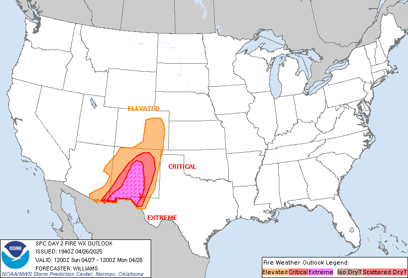
SPC Day 2 Fire Weather Outlook

Day 2 Fire Weather Outlook
NWS Storm Prediction Center Norman OK
0100 PM CST Tue Nov 12 2024

Valid 131200Z - 141200Z

The Elevated area was expanded slightly based on the latest
high-resolution forecast guidance and current dry/windy conditions.
Elsewhere, locally elevated conditions are possible in portions in
southwest Texas and along the Sierra Front. Locally elevated
conditions are also possible in the Appalachians from
Tennessee-North Carolina border through the West Virginia-Virginia
border as southeast winds strengthen with some downslope enhancement
ahead of precipitation Wednesday night.

..Nauslar.. 11/12/2024

.PREV DISCUSSION... /ISSUED 0200 AM CST Tue Nov 12 2024/

...Synopsis...
Gusty post-frontal off-shore flow will continue across portions of
the Northeast from far eastern PA and southern NJ extending
northeast through southern New England. A very dry air mass will
remain in place with relative humidity reductions to around 30-35
percent likely. Given the drought conditions and receptive fuels in
this region, an Elevated delineation was maintained with this
outlook. Locally Critical conditions may be possible, though the
limited spatial extent of this threat precludes the need to include
a Critical area at this time.

...Please see www.spc.noaa.gov/fire for graphic product...
Read more

by SPC Forecast Products | Nov 12, 2024 | Weather and Emergency Alerts
SPC Day 2 Fire Weather Outlook

Day 2 Fire Weather Outlook
NWS Storm Prediction Center Norman OK
0100 PM CST Tue Nov 12 2024

Valid 131200Z - 141200Z

The Elevated area was expanded slightly based on the latest
high-resolution forecast guidance and current dry/windy conditions.
Elsewhere, locally elevated conditions are possible in portions in
southwest Texas and along the Sierra Front. Locally elevated
conditions are also possible in the Appalachians from
Tennessee-North Carolina border through the West Virginia-Virginia
border as southeast winds strengthen with some downslope enhancement
ahead of precipitation Wednesday night.

..Nauslar.. 11/12/2024

.PREV DISCUSSION... /ISSUED 0200 AM CST Tue Nov 12 2024/

...Synopsis...
Gusty post-frontal off-shore flow will continue across portions of
the Northeast from far eastern PA and southern NJ extending
northeast through southern New England. A very dry air mass will
remain in place with relative humidity reductions to around 30-35
percent likely. Given the drought conditions and receptive fuels in
this region, an Elevated delineation was maintained with this
outlook. Locally Critical conditions may be possible, though the
limited spatial extent of this threat precludes the need to include
a Critical area at this time.

...Please see www.spc.noaa.gov/fire for graphic product...
Read more

by SPC Forecast Products | Nov 12, 2024 | Weather and Emergency Alerts
SPC 1730Z Day 2 Outlook

Day 2 Convective Outlook
NWS Storm Prediction Center Norman OK
1115 AM CST Tue Nov 12 2024

Valid 131200Z - 141200Z

...THERE IS A MARGINAL RISK OF SEVERE THUNDERSTORMS ACROSS THE LOWER
MISSISSIPPI VALLEY/CENTRAL GULF COAST REGION...AND COASTAL PORTIONS
OF PACIFIC NORTHWEST...

...SUMMARY...
A marginal tornado/wind threat is apparent on Wednesday afternoon
into Wednesday night across a part of the central Gulf Coast States.
Thunderstorms with strong to locally severe gusts are also possible
near the immediate coasts of Washington, Oregon, and northern
California.

...Synopsis...
A shortwave trough is forecast to move from the Plains through the
MS Valley on Wednesday, becoming more negatively tilted as it does.
An occluded surface low associated with this system will begin the
period over the mid MO Valley before moving eastward across IA and
reaching the northern IL early Thursday morning. More consequently
for the severe-weather potential, a secondary triple-point low is
expected to progress eastward across the northern portion of the
Southeast states, along the northern edge of an eastward-evolving
warm sector. Cold front associated with this low will gradually move
eastward across the Southeast states during the day.

Farther west, an upper-level trough is forecast to progress farther
inland across the western CONUS, as an embedded shortwave trough
moves across northern CA into the interior Northwest/northern Great
Basin.

...Lower Mississippi Valley/Central Gulf Coast...
General expectation is for a triple-point surface low to evolve over
the Mid-South vicinity through the early afternoon as low-level
moisture continues to advect northward across the central Gulf Coast
region. Dewpoints in the upper 60s/low 70s are anticipated ahead of
this low and associated cold front. The airmass is expected to
destabilize amid this low-level moisture, but overall buoyancy will
still be modest given the lack of steep lapse rates. The combination
of destabilization and increasing ascent is forecast to result in
thunderstorm development across the warm sector, but along and ahead
of the eastward-progressing cold front.

The stronger shear will likely be displaced north of the stronger
buoyancy, but enough shear is expected across the warm sector to
support organized storms if updrafts can persist and deepen. This
evolution could support a few marginal supercells and/or stronger
clusters during the afternoon and evening, with a threat of locally
damaging winds and possibly a tornado or two.

Elevated storms will also be possible through the day/evening to the
north of the richer surface moisture. While effective shear will be
sufficient for a few strong elevated storms, the severe potential
with northward extent will tend to be limited by weak midlevel lapse
rates and generally marginal buoyancy.

...WA/OR/Northern CA coasts...
Cold mid-level temperatures (i.e. -24 to -28 deg C at 500 mb)
associated with the upper trough are expected to spread eastward
throughout the day. These cold mid-level temperatures and associated
steep mid-level lapse rates will contribute to modest buoyancy along
the coastal portions of the Pacific Northwest. Highest storm
coverage is anticipated over the northern CA coast vicinity from the
late morning into the early afternoon along as the frontal band
moves through, but persistent forcing for ascent within this
modestly buoyant airmass is expected to result in more cellular
storms throughout the remainder of the afternoon and evening. A more
linear mode is anticipated within the frontal band, with a few
convectively enhanced gusts possible. Low-topped cellular activity
is anticipated in the wake of the frontal band, with a few instances
of small hail, and potentially even a brief tornado, possible.

..Mosier.. 11/12/2024
Read more


